Searching for the English Origin, Migration and Evolution of the Charlottetown City Plan: 1666-1771
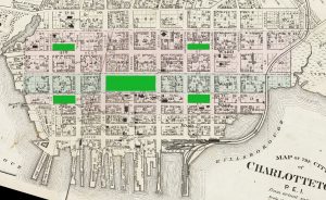
Things are never quite the way they seem to be. Take, for example, the plan of the city of Charlottetown with its four green areas, with no political function, that flank the very political central square. The reason for its present appearance should be quite simply that Governor Patterson, not liking the plan that Morris had presented in 1768, changed it. All that is true. But what was the ultimate inspiration of the change?
Detail of the Charlottetown map from Meacham’s ATLAS of 1880.
The evidence available to trace the origins of green spaces set aside for the common folk encourages us to go back a long time, to other centuries, other countries and other cultural aspirations.
The Great Fire of London
On Sunday, September 2, 1666, and continuing to Thursday the 6th, a terrible fire swept through the city of London, and destroyed most of the old mediaeval city that had grown within the old Roman walls over the centuries.
https://en.wikipedia.org/wiki/Great_Fire_of_London
Although the loss of life was relatively low, the social, commercial, religious and administrative core of the city was completely obliterated. Artists gloried in vying with one another to depict the intensity and brightness of the blaze. Here is one such dramatic view.
Anonymous – The Fire of London, September 1666, National Maritime Museum, Greenwich.

King Charles II, in a desperate attempt, to rebuild his city, which already, in the previous year had been devastated by an outbreak of the bubonic plague, looked around for proposals on how the city would be restored. A lot was hanging on his decision because this precise moment coincided with a completely new view of modern city planning. It had its early origins in the Rome of Pope Julius II, who was fighting the disaster of the Protestant Reformation with pomp and splendour never seen in the city since the height of the Roman Empire. Michelangelo was bullied into helping out.
At the end of the Sixteenth Century Pope Sixtus V created the essence of the Baroque City by having his architect Domenico Fontana (1543 – 1607) do extensive work on major basilicas, including Saint Peter’s, and to open up long vistas that connected the great pilgrimage churches by wide avenues that were given spectacular vertical emphasis by the placement of a number of great granite obelisks brought to the city in Imperial times. Fontana’s skill as an engineer in moving those giant obelisks, using the technology of the time – rope, pulleys and blocking timber – created an effect unlike anything ever seen before.
Schematic drawing of the Rome of Pope Sixtus V, from Giedion, Sigfried, Space, Time and Architecture – the Growth of a New Tradition, p. 79.

The plan was all-encompassing and sought to link all the essential papal institutions with the Seven Churches of Rome, the focus of pilgrimages, the granting of indulgences, and source of untold sums of money.
To help you appreciate the enormity and drama of this project, look at this tiny bird’s eye view of the panorama from the northern gate of the city, where most visitors found themselves upon arrival. Three long straight avenues were cut through the congested mediaeval city that had grown there, two almost identical churches built to frame the main street, the Corso, and a great granite obelisk made to line up with others at the ends of these long vistas. This tiny painting by the great topographer Vanvitelli, as the Italians called him, captures exactly the spirit of the new way of articulating public space.
Gaspar van Wittel (1653–1736) called Vanvitelli, View of the Piazza del Popolo, c. 1680, tempera on parchment, laid down on a wooden board, 206 by 407mm, Private collection on sale at Sotheby’s.

We can best appreciate the changes that took place in the 50 years following Sixtus V’s plans by studying Giovanni Battista Nolli’s (1701-56), huge 12-sheet plan of the city as it had evolved to 1744. Here we see the violent thrust of these vistas as they make their way over or through every obstacle until they reach the great churches and holy sites that were the destinations of pilgrims to the Holy City.

Yale University Art Gallery
Here is a single-plate detail of the north gate, the Porta del Popolo, opening up into the piazza of that name. By Napoleonic times the Piazza del Popolo would be transformed into the ultimate Neoclassical explosion we experience today by the huge exedrae added by Giuseppe Valadier.
Giambattista Nolli, Nuova Pianta di Roma, data in luce de G. Nolli, print of the copperplate containing the Campo Marzo, 1748, British Library, Maps 7.TAB.4

In 1661, the French king Louis XIV, Charles II’s hated rival, had begun to transform a chateau at Versailles that had been built over a hunting lodge into a palace which, at its completion in 1715, became not only the model for a royal palace that every monarch in Europe would aspire to imitate, but the model for new cities glorifying the Divine Right of Kings. Versailles became a city with formal gardens that extended for miles.

Vue aérienne du domaine de Versailles par ToucanWings – Creative Commons
Charles II expected that his great architect Christopher Wren would produce a viable plan for a new city in the style of the palace and city of Versailles, the standard for the civilised world. This is the plan Wren produced. The title and information in the cartouche are in Latin, so that everybody in the European world could read what the new London would consist of. The plan , if executed, would have produced a city that would have rivalled Rome and Versailles. Its execution would require that the social classes be rigidly separated by city architecture. It would have created a nightmare for property owners who, for centuries had prospered on the same spot. How could property titles ever be redefined? This was not to be, and London was rebuilt in fits and starts – with some wonderful grand topographical features – well into the Nineteenth Century. It is still changing, some might say, with the regular addition of monumentally grotesque structures.
Wren, Sir Christopher, Ichnographia urbis Londinii… (A Plan of the City of London, after the great FIRE, in the Year of Our Lord 1666.), height: 19 in (48.2 cm); width: 27.5 in (69.8 cm), 1744. Public Domain.

The Wren plan, that was engraved and printed again and again – one wonders why? – is full of elements that we saw in the detail of the Nolli map of Rome: it is all avenues and vistas with squares and piazzas crying out for public display. It coincides with Baroque art, architecture and music at their height – and all aimed for effect and display of a regal presence.
The Competition for a New City Plan
This map from Wikipedia graphically illustrates the extent of the fire and the vast opportunities for creating a grand capital for the Britain that could compete with Rome and Versailles in splendour and drama, but also bring into effect new building regulations that would forever replace the convoluted congestion of Mediaeval streets with wide avenues that would act as firebreaks. New construction was required to be as fireproof as possible to avert another such catastrophe.

The Interim Measure of Moorfields
https://en.wikipedia.org/wiki/Moorfields
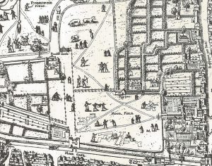
When you look at the map above, at the top centre right, just beyond the Roman wall, you see an area divided into four sections called Moorfields. A gate called Moor Gate has been cut through the ancient walls to provide access. Moorfields, as its name suggests, was former wetlands that over time had been drained and turned into a large dry open area that had been divided into sections. After the Great Fire refugees were encouraged to set up temporary camps there, even though the king would have preferred that they leave London altogether, but all the same, many actually settled in that area.
An impression of these open spaces can be gained from this detail from what is believed to be the earliest map of London, engraved on 15 copperplate sections some time between 1553 and 1559 and called “The Copperplate Map.” It was 3” 8” by 7’ 5” and may have required 15 copper plates to print the pages that would be glued together. The map does not survive but three of the plates were found between 1962 and 1997 and after cleaning, impressions like this one, were made. People are shown pasturing animals, hunting and even, it seems, bleaching clothes and drying them in the sun (Urban, GM, p. 380). All this open ground had survived to the time of the fire, and it was here that many fled for temporary settlement.
https://en.wikipedia.org/wiki/Copperplate_map_of_London
Detail of Moorfields from the Copperplate Map of London, the earliest known map of the city engraved on 15 copperplates. Engraved between 1553-59. Museum of London (1963).
At this moment my readers may be in a state of advanced confusion about what seems like a major digression from the evolution of the Charlottetown map with four green public areas. Please bear with me. I frequently say in my posts that things always connect, and soon you will see how Charlottetown connects – perhaps exiguously – with Moorfields.
Plans by other contenders
The most amazing plans for rebuilding London were submitted by a number of persons apart from Wren. Sir John Evelyn submitted a grid plan fantasy with Baroque squares and vistas. Sir John, who liked to compare a library to a temple of worship, was close to the king and his design for the new London was based on his travels in France and Italy, where he experienced Baroque grandeur at first hand.
http://digitalarchive.mcmaster.ca/islandora/object/macrepo%3A31438
Evelyn, John, Sir John Evelyn’s Plan for Rebuilding the City of London after the Great Fire in 1666. Illustration RIBA

Robert Hooke, the great microscopist who published a magnified image of the plague-bearing flea, also presented a plan. By the way, Hooke was a fascinating person who published the first book ever on microscopical observation.
http://roberthooke.org.uk/?page_id=166 https://en.wikipedia.org/wiki/Robert_Hooke
Hooke, Robert, Plan for the City of London, German edition, London Metropolitan Archives, City of London.

Valentine Knight proposed a plan that would have a canal with toll gates surrounding the new city. An enraged king had him imprisoned.
https://www.raremaps.com/gallery/detail/80972
Knight, Valentine, Plan of London, engraving, 13.5 x 10.5 inches, first printed September 20 1666, this re-issue circa 1740. Barry Lawrence Ruderman Antique Maps Inc.

Richard Newcourt (d. 1679)
T. Cook, engraver, Richard Newcourt, engraving on copper, published by William Richardson, York House, Strand, 1812. National Portrait Gallery, London.

Newcourt was another contender for the glory of providing a suitable map for rebuilding London. He had already achieved fame by producing a map of London in 1658 that preserves an image of the city before it was destroyed by the fire. Of all the proposals Newcourt’s seems to have garnered the least amount of interest. It was more intellectual than practical, and called for the obliteration of everything that was destroyed, and even that which had survived. This is a strange proposal coming from a man who just 8 years before had produced a map of London that was intimate in the exactitude of its detail.
https://en.wikipedia.org/wiki/Richard_Newcourt_(cartographer)
Newcourt’s attitude to planning is well described by T F Reddaway (1939) in an article he wrote after he had rediscovered the original rebuilding plans and the commentary that accompanied them.
Taking as his fundamental that the old city had been crowded too closely together, he planned “a great expatiation and enlargement.” His new London went boldly forth three furlongs beyond the most northerly point of the old wall, gaining ground, much of it unbuilt, sufficient both for Wren’s broad streets and the inhabitants whom Wren’s scheme would certainly have extruded. On this the citizens could build with space for everything that they held essential to their life. Markets and fairs, musters and pageants, could all be accommodated and men enabled, as in the days before the growth of the previous hundred years, to exercise their freedom within their Freedom. Utilitarian rather than demonstrative, the ideas behind the plan can be understood only in relation to their age.
Reddaway (1939), p. 157
It is worthwhile reading the entire article to discover what an extraordinary man Newcourt was, and to the surprising degree to which he cared about ordinary people.
https://bunker2.zlibcdn.com/dtoken/9f81310dd6ce2fb3d75403d519916eac/40101824.pdf
After the fire Newcourt produced two versions of this extraordinary plan for rebuilding the city that carried the concept of the grid to the realm of Platonic ideals. The difference in the two versions presented alternatives to the size of his design.
Richard Newcourt, First plan for the rebuilding of London, ink drawing, City of London, London Metropolitan Archives, CLC/481/MS03441.

This is what Newcourt proposed (with a variation) for the new city of London. He suggested a square grid of 64 equal portions, except that from the whole, a great central square, equal to four portions of the grid, would dominate the plan. Four more single portions would be set aside, in the centre of the four corner squares, that would serve as public spaces, except that one of the squares would have to contain the new Saint Paul’s Cathedral. The plan was so tightly positioned that the lower right portion abutted the Tower of London. Each of the remaining 55 blocks would have formed a single parish and would have a church placed at its centre. This new city would be set off from the Thames by a forecourt or wharf 60 yards wide, where the lower storey of all the facing buildings would form a continuous arcade for shade and protection against the weather.

We are reminded of the scale of this proposal when, looking at this detail of the map, we see that Moorfields begins at the upper edge of the central square. We also realise that the old Roman wall is to be completely demolished so that the new city can expand, unobstructed, to the north.
In language carefully attuned to the quasi-hysterical probing of state security, Newcourt, in his wonderful description of his project (which I enclose below as a pdf) writes a few sentences that have a sweetness to them – unusual for the times – where he thinks of ordinary people enjoying the open spaces he had designed (with the assumed consent of the king) for their use in a whole variety of ways. (At this time, in square brackets, I am unable to give a meaning to several words or expressions).
“As to the buildings towards each main street, I would wish they might all be of upright work, of one and the same form, with paynthouses [penthouse?] of about five or six foot broad, under which there may be an casy [encased?] walk of about four foot over, of smooth hewn stone, for the easier passing to and again of the people, specially of such as are old or diseased in their feet; over which paynthouses, the inhabitants may erect balconies, if they please. (p. 254)
…
“Then for the large space remaining in circuit about the same, there may be kept the constant daily market formerly kept in Cheapside. The whole body also of the militia of the city, or any part thereof, may be drawn thither at fitting time to be mustered, viewed and exercised, and many other omissions may there be performed: and if this square plot seem to lie too flat and low to carry off the water, it may be raised to any convenient height whatsoever, with part of the rubbish of the old city.
“As for the other four piatzos; upon that on the south-west falls, of necessity, the great church of St. Paul’s; and it so falls, as will no way hinder or obstruct the streets, so that may be set apart wholly for the church. In the vacant space thereof, may be kept a weekly market upon any convenient day, and a Poule’s fair once a year, (by the king’s gracious charter,) if the church thinks fit to obtain the same.
“Upon the other three, there may also be kept three public markets, upon three other days of the week. And whereas, into the north-west piatzo, may be translated the great fair of St. Bartholomew’s, heretofore kept in Smithfield; so unto the other two (by the like gracious charter of his majesty) may be obtained two other noble fairs, at two convenient seasons of the year; which fairs may be of great advantage and profit unto the city. And so these piatzos will not only be of general use and benefit in divers respects, but also will be the principal ornament and glory of the city, as partly may be seen by the piatzo in Covent Garden. They all being built on arches as the same is. (p. 255)
…
and for the inner part of the square, they may convert to brave walks and terraces, and grandeur of delight; and in the midst of each square, they may erect and raise a stately mount (surmounting the buildings of the city, which may be raised out of the rubbish of the burnt houses, and may save the charges of exportation thereof out of the town; all which will in a short time be manured and made fertile for the planting of trees, herbs and flowers, and converted into brave walks and ascents, where the companies may walk and recreate themselves, and from the top of their mount may have a brave prospect, and draw fresh and wholesome air at all convenient seasons, without walking further abroad into the fields; and if I mistake not in the measure, the ground will bear it well enough, the squares of the first map being more than eleven acres, and of the second map more than fifteen. (pp. 256-57)
This description is full of a gentle caring humanity the likes of which we simply do not encounter in any accounts of this or subsequent periods of the colonial era.
There is a very interesting speculation by Sholto and Reuben Percy in their wide-ranging Percy Histories, written in 1823, after London had been recovering and rebuilding for 150 years. Strangely, not impressed with the way things have gone, they concentrate on Wren and Newcourt, and are full of optimistic memories of how these plans could have succeeded. Here is a portion of what they write:
The vast space allotted in the plans, both of Wren and Newcourt, to open streets and squares, forms so striking a contrast to what we now meet with in perambulating the city, as to leave one, at first, in doubt as to the possibility there was of carrying them into effect. –But the explanations given by the projectors show clearly, that in either case all this space might have been gained for the public, without the least sacrifice of private right. The plan of Wren would have left more ground to build upon than Newcourt’s, for he proposed, that all the church-yards should he placed out of the town; and in both these respects, it was certainly the better plan of the two. The citizens should have selected the good points of each; they might have added some, equally good, from other plans that were offered to them; and had all this been done, their city would have arisen and remained without a rival in the world for magnificence and beauty.
(Percy, p. 122).
Perhaps now you are beginning to see the reason for my great digression from what should have been a simple story about how Charlottetown got its four green squares. In the following narrative you will see how possibly, Newcourt’s plan, and most certainly the idea of Moorfields, crossed the sea to America, in the very early stages of being colonised with British provinces.
Plans for the Thirteen Colonies of North America
Starting in the Seventeenth Century Britain began to establish a series of colonies along the Atlantic seaboard that would prosper in highly individual ways. They had in common the English language and religion of often contrasting denominations, and their political setup, and constitutional and legal systems, were very similar. By the middle of the Eighteenth Century, while France was losing its empire in North America to the British, the American Colonies themselves had endured enough of incompetent and unfair British demands that in April 1775 they began fighting the American Revolutionary War and declared full independence in July of 1776. Thus, both France and England, with their eyes and desires focussed on other fantastical unobtainable prizes, and not thinking for a moment of all those hard-working colonists who deserved immense respect for the vision and labours, lost the vast incalculable richness of North America.

The Thirteen Colonies that became the United States of America. Map from Wikipedia.
The province of Pennsylvania was the EIGHTH colony to be established by a gift of the Crown. King Charles II, perhaps feeling fleeting remorse for the treatment that had been meted out to Admiral Sir William Penn, gave his son William the colony of Pennsylvania – the forest of Penn, with his own charter.

Pennsylvania was one of two colonies founded during the Restoration period in British Seventeenth Century history and became one of the original Thirteen Colonies. The colony’s charter remained in the hands of the Penn family until the American Revolution. The colony attracted a strange combination of settlers, led by members of the Quaker sect that hoped for religious serenity and financial prosperity in the new land. Germans also came in large numbers and established the Mennonite and Amish communities. And Scots-Irish settlers emigrated from Northern Ireland and would push into the western frontier. The local tribe of aboriginals were called the Lenape and attempted to live in peaceful coexistence with the Quakers who, like all Christians, saw these unbaptised creatures of the forest as subhuman savages. This is rather ironic because at home in England the Quakers, with their peculiar ways, had been demonised by the Church of England. Charity, often associated with Christianity, can have the narrowest boundaries imaginable. By the time of the Revolution the Lenape had already been forced to move westward to get out of the way of settlement. Wonderfully, they still exist today.
The site chosen for the capital city of the new colony was up the Delaware River in Eastern Pennsylvania. The name chosen for the city was made up of two Greek words, φίλος (phílos) meaning beloved and ἀδελφός (adelphós) meaning brother or brotherly. So, it was the city of brotherly love.
In 1683 William Penn, an English Quaker, founded Philadelphia which remained the capital city of the colony until the Revolution. It became a meeting place for those who would plan and execute the Revolution. It is where the Declaration of Independence was signed. In 1787, at the Philadelphia Convention, the American Constitution was ratified. The Americans, ever conscious of the fact that the concept of their nation was rooted in antique ideals, never failed to produce propaganda paintings – costume drama – that recorded every great moment in the formation of their country. This process of celebrating and interpreting the past continues to this day. The scene below, painted as recently as 1940 by an artist who specialised skilfully in such genre work, records the moment when the US Constitution was signed at the Constitutional Convention held at Independence Hall in Philadelphia on September 17, 1787.
Howard Chandler Christy, Scene at the Signing of the Constitution of the United States, oil on canvas, 1940.

For the most part Philadelphia, flanked by the Delaware and Schuylkill Rivers, is fairly flat country except for the rise in the northwestern quarter. It was assumed from the start that the city would be designed on a grid system that would become almost universal in British North America. As I mentioned earlier the grid system with streets leading to a central square had its modern origins in the Thirteenth Century. The design was clean and neat, and practical in that administrative buildings could dominate the great central place of assembly while the wide streets, providing easy movement, also served as firebreaks at times of crisis, and were even described as a place where peoples’ possessions could be moved while the house burned down.
Penn presents his concept of the new capital
There survives an eight-page letter, printed in in 1683 in sufficient numbers that examples of it still survive today, which set out the why and wherefore for this particular project. This is what the collection of pages looks like. I reproduce it because it is a significant monument in that the founder of a city shares his dreams with a wider public all over the world. Samuel Holland’s vision for the Colony of Saint John’s Island was secret, contained in a letter to government officials in London.
A Letter from William Penn, Proprietary and Governor of Pennsylvania in America, & c. [to the Committee of the Free Society of Traders of that Province, dated Philadelphia, 16 August 1683]. Barry Lawrence Ruderman Map Collection – Spotlight at Stanford.


This letter is so interesting, and full of things that were on the minds of the colonisers of the New World that I attach it here.
William Penn’s letter and documents – 1683
At the end of his long descriptive letter Penn attaches a description of his new city written by Thomas Holme (1624-95), his surveyor general, who on April 18, 1682, while still in England, had been instructed to lay out Penn’s “greene country towne.”
https://explorepahistory.com/hmarker.php?markerId=1-A-2A
https://en.wikipedia.org/wiki/Thomas_Holme
Thomas Holme, A Portraiture of the City/of/ Philadelphia/ in the Province of/ Pennsylvania/ in/ America/ by Thomas Holme Surveyor General. / Sold by John Thornton in the Monories/ and Andrew Sowle in Shoreditch. / London. 1683. Copperplate engraving, attached to the text of Holme’s advertisement. Barry Lawrence Ruderman Map Collection – Spotlight at Stanford.

I insert the whole of the notice appended at the end of the letter because it is so specific in its instructions, and so willing to point out the ways in which everything is planned for the good of the colonists. This plan of the city was engraved in large numbers as a propaganda piece and to this day it is possible to find prints of it in antique shops. This very wide circulation meant that the map, and the ideas attached to it, would be there to influence other founders of colonies, and perhaps, more importantly, be there, still vibrant, a century later when the capital of Georgia, Savannah, was planned. I deliberately highlight in red typeface the sentence where Penn specifically mentions Moorfields and the uses to which it was put after the Great Fire, as a desirable feature of his new city. And so, what happened in London, crosses the Atlantic as an idea, and then a detail on a map, and deep inside Pennsylvania is laid out on the ground of the new city by Thomas Holmes.
It should be noted that at this time I do not know whether it was Penn or Holmes who promoted the four green areas inspired by the Moorfields. Perhaps in time this will become clearer.
A short Advertisement
Upon the Situation and Extent of the CITY of
PHILADELPHIA
And the ensuing PLATFORM thereof.
By the Surveyor General.
The City of Philadelphia now extends in Length, from River to River, two Miles, and in Breadth near a Mile; and the Governor, as a further manifestation of his Kindness to the Purchasers, hath freely given them their respective Lots in the City, without defalcation of any their Quantities of purchased Lands; and as its now placed and modelled between two Navigable Rivers upon a Neck of Land, and that Ships may ride in good Anchorage, in fix or eight Fathom Water in both Rivers, close to the City, and the Land of the City level, dry and wholesome; fuch a Situation is scarce to be paralleled.
The Model of the City appears by a small Draught now made, and may hereafter, when time permits, be augmented; and becaufe there is not room to express the Purchasers Names in the Draught, I have therefore drawn Directions of Reference, by way of Numbers, whereby may be known each man’s Lot and Place in the City.
The City is so ordered now, by the Governor’s Care and Prudence, that it hath a Front to each River, one half at Delaware, the other at Schuylkill; and though all this cannot make way for Small Purchasers to be in the Fronts, yet they are placed in the next Streets, contiguous to each Front, viz, all Purchasers of one Thousand Acres, and upwards, have the Fronts (and the High-Street) and to every five Thousand Acres Purchase, in the Front about an Acre, and the smaller Purchasers about half an Acre in the backward Street; by which means the least have room enough for House, Garden and small Orchard, to the great Content and Satisfaction of all here concerned.
The City (as the Model shews) consists of a large Front-street to each River, and a High-street (near the middle) from Front (or River) to front, of one hundred foot broad, and a broad Street in the middle of the City, from fide to fide, of the like breadth. In the Center of the City, is a Square of Ten Acres; at each Angle are to be Houfes for public Affairs, as a Meeting‑Houfe, Assembly or State-Houfe, Market Houfe, School-Houfe, and several other Buildings for Public Concerns. There are also in each Quarter of the City, a Square of eight Acres, to be for the like Uses, as the Moor-fields in London; and eight Streets (befides the said High Street) that run from front to front, and twenty Streets (befides the broad-street) that run across the City, from fide to fide; all thefe Streets are of fifty Foot breadth.

And so Philadelphia is laid out, and begins to emerge from the solid wilderness, street after street, square after square, and in time, one green area after another.
A caveat...
Richard Newcourt’s plan seems never to have been engraved, unlike those of all the other contenders, nor does a printed version of his accompanying description appear until 1805 (Hughson). Both plan and text would have been, with all the others, available in the records of the city of London. This is the weak point in my argument that Newcourt, along with the vision of Moorfields, jumped across the Atlantic with Penn and his surveyor-general Holme, 17 years later in 1683. Had Holme or Penn seen the Newcourt plan, or a copy of it, along with all the others in the London archives? To me it seems likely, but some of my readers may be far more demanding than I. One might even speculate that Penn and/or Holmes met Newcourt and obtained knowledge directly from the source. Had Newcourt been Quaker the likelihood of this happening would have increased greatly. The knowledge I have at the moment, in my rural isolation, will in time, hopefully, be augmented, and this vital link in the chain will be strengthened.
We are fortunate to have this bird’s eye view lithograph showing the city in 1702, showing how much development has taken place in 20 years. It makes us wonder what our three county capitals on Saint John’s Island would have looked like if seen from such a vantage point.
Smith & Cremens, Detail from Philadelphia in 1702, one-stone lithograph, modern tinting, 48 x 65 cm, F.J. Wade, Lithographer, Philadelphia, 1875. © Library Company of Philadelphia.

A Colony that Never Was: The 1717 Margravate of Azilia
https://kaltura.uga.edu/media/t/1_q8chznfx/189176203
A margrave is the noble title of a man who, in earlier centuries in Europe commanded defenses relating to the Holy Roman Empire. His city was called a margravate. In 1717 Sir Robert Montgomery proposed that such a colony should be established at Azilia, on a spot between the Altahama and Savannah Rivers.
A map was drawn and printed and inserted into a booklet in which the new colony was described and promoted. It is very much a utopian idea of colossal proportions, consisting of a fortified grid containing 256,000 acres of land. In the centre square was the governor’s mansion, 116 estates belonging to the gentry, and along the edges was the farmland to be worked by indentured peasants. They lived in homes that were arranged in an orderly fashion at the edge of the grid. This was a departure from the grid town plan that was in the process of evolving at that time. The most spectacular feature of the plan however, was the insertion of four great leafy squares of parkland, placed along the centre square diagonals, and as large as the central square itself.
Nothing came of it because of a major Indian war that broke out at that time. But the printed plan and booklet survived, were available to subsequent grid town planners in the New World. This project is yet more evidence that new colonial experiments, at least a very few of them, found the grid plan with green areas for the populace an idea worth pursuing.
Sir Robert Montgomery, A Plan representing the Form of Setling the Districts, or Country Divisions in the Margravate of Azilia, 1717, from Mountgomery [sic], Sir Robert, A discourse concerning the design’d establishment of a new colony to the south of Carolina, in the most delightful country of the universe, 1717. Library of Congress, bibliographic number, b53961766.

Here is a pdf copy of the booklet by Montgomery.
Is this a book, expressing a glowing dream, and a map, that General Oglethorpe had access to 17 years later when he was planning Savannah in 1734? Copies of the booklet and map are still available in antique shops today.
Savannah, Georgia
In 1733 the town of Savannah, Georgia, at the very bottom of the line of British provinces, was established by General James Oglethorpe, and he too settled upon a plan based on a grid system. This is what his surveyor saw in March of 1734, when the colony was just begun and Oglethorpe was still living in a tent.
A View of Savannah as it stood the 20th of March, 1734. To the Hon’ble the Trustees for establishing the Colony of Georgia in America This View of the Town of Savannah is humbly dedicated by their Honours Obliged and most Obedient Servant Peter Gordon. British Library, Shelfmark: Maps 1. Tab.44.

When General James Oglethorpe, settled on his plan for his new capital city he too used a grid system, but with the most extraordinary difference: there were four public squares for the people!
The Savannah city grid, planned under the direction of Oglethorpe, was a masterpiece of civic space designed with the dignity and pleasure of the citizens in mind. In the original plan of 1733, there were four green public spaces. Each square was surrounded by “wards” of eight blocks, producing this pattern.

For the first time in the Eighteenth Century a town had green parks for the citizens, something which in the past had been the sole preserve of aristocrats and the upper classes. It was a very democratic statement in a new city that would tragically in 1750 end up involved in the slave trade. Two more squares were added in 1736 and more continued to be added as the city expanded until there were 24. It was an extraordinary project and an amazing achievement.

Reps, (p. 201.)
Nearly all the publicity generated about the historic origins of this city give high praise to General Oglethorpe for having invented the park and ward module that could be repeated as required to accommodate expansion. It was not his idea – indeed, the idea had been born after the Great Fire of London in 1666 when Richard Newcourt came forward with his eccentric plans that also incorporated green areas for the people. It seems likely that General Oglethorpe got his plan for Savannah, from the example of Philadelphia – now a most famous city – that had been laid out in that fashion 51 years before.
Here is another of those bird’s eye views, this time of Savannah, that give you an idea of how colonial towns built on the grid system developed.
Louis Firman Cerveau, Painting of Savannah in 1837, which hangs in Hodgson Hall, the Society’s headquarters – Georgia Historical Society.

And now, back to Charlottetown and its colonial grid plan

Holland’s great map of the island of Saint John is perhaps the most perfect, and most detailed example, of any colony planned in British North America. Not only is every square inch of the colony accounted for, because at some time, in the years to come, it would have the name of a property owner attached to it.
But the Island colony was never meant to be a great farm. Everything was set up in the ancient feudal system of great estates peopled with grateful tenants who served their masters and never made much of themselves except to pay the annual rent on land that for the most part, they could never own.
There were three capital cities, one for each county, and these cities were all based on the grid plan that had been in use, in one way or another, since the Middle Ages.
Holland set aside quite large areas of land for these capital cities which may appear to us to be rather a disorganised blob. But it had all been measured and the colonial office specified that it was to be divided into three sections: the city in a grid plan, a band of common land around the city for pasture, gardening and the harvesting of wood, and beyond that, a great area reserved for the certain expansion of the capital city.

Charlottetown was laid out in 1768 by Charles Morris, the Surveyor-General from Halifax, but the first Governor of the Colony of the island of Saint John, Walter Patterson, did not like the plan, or was convinced not to like it by his Chief-Surveyor, Thomas Wright, who, when he was 18, was posted to Savannah Georgia to be apprenticed to General Oglethorpe. In turn, Wright was able to propose a grid plan based on what I have been discussing in great detail in the course of this essay – the four green areas that were a democratic gesture to the inhabitants of the city, going back to the ideas expressed by Richard Newcourt in London in 1668.
And here it is, in a beautiful map dating from circa 1800 found in the Public Archives.
Anon., Charlottetown c 1800 – PARO PEI 0397 (green tint added by R. Porter).

And of course, we must finish with our own bird’s eye view of the city, this time just over 100 years after the four square plan had been laid on mostly featureless, slightly swampy ground. Here is our city of democracy, firmly planted in a feudal government that would last until the middle of the Nineteenth Century.
1878 PANORAMIC VIEW OF/ CHARLOTTETOWN/ PRINCE EDWARD ISLAND/ 1878/, signed A. Ruger in the lower left-hand corner of the image. Scan of reproduction published by the Heritage Foundation in 1983. (green tint added by R. Porter).

British Colonial Town Planning After Charlottetown
After the American Revolution came to an end there was a rush of Loyalist and other emigration to the British Colonies in North America, particularly Ontario. By 1789 an official set of instructions had been published by Lord Dorchester providing detailed instructions and plans for various kinds of settlements that might be planned. The most obvious plans were for towns on the edge of lakes and rivers, but also for inland settlements. The basic core grid for all of these appears – indeed, must have – been based on Thomas Wright’s Charlottetown model. This subject will form the basis for discussion in the next post.
Resources
______________ Journal of the House of Assembly of Prince Edward Island, Fourth Session of the Fifteenth General Assembly, Appendix D, pp. 11-13, Cooper & Bremner, Charlottetown, 1841.
______________ “Moorfields,” Historical introduction, Pages 88-90, Survey of London: Volume 8, Shoreditch. Originally published by London County Council, London, 1922.
______________ Laws of the Indies, Wikipedia,
Alberti, Leon Battista, On the Art of Building in Ten Books (c. 1450), translated by Joseph Rykwert, Neil Leach and Robert Taverner, The MIT Press, Cambridge, Mass., 1988, 1996.
BDA Landscape Architects, Charlottetown Heritage Squares – Conceptual Master Plans and Design Guidelines, Riverview, New Brunswick, 2012.
Boerefijn, W.N.A (Wim), The foundation, planning and building of new towns in the 13th and 14th centuries in Europe. An architectural-historical research into urban form and its creation. PhD. thesis Universiteit van Amsterdam, 2010.
Corcoran, Imma, Thomas Holme, 1624-1695: Surveyor General of Pennsylvania, American Philosophical Society, Philadelphia, 1992. (Sadly, I’ve not read this. I can’t find an affordable copy.)
Cust, Lionel Henry, Newcourt Richard (d. 1679), Dictionary of National Biography, 1885-1900, Volume 40.
Dubourg, Jacques, Histoire des Bastides – Les Villes Neuves du Moyen Age, Editions Sud Ouest, Imprimé par Polina à Luçon (85), 2002.
Giedion, Sigfried, Space, Time and Architecture – the Growth of a New Tradition, Harvard University Press, Fourth Edition, 1961, paperback 2008.
Greaves, Sofia, and Andrew Wallace-Hadrill, Editors, Rome and the Colonial City: Rethinking the Grid, Oxbow Books, Oxford, 2022.
Hughson LL.D., David, London; being an accurate History and Description of the British Metropolis and its Neighbourhood to Thirty Miles Extent, from an actual Perambulation, Vol. I, printed by W. Stratford, Crown Court, Temple Bar, for J. Stratford, No. 112, Holborn Hill. London, 1805. (Newcourt description pp. 251-258).
Kashima, Akihiro, ‘A Perspective of “Diversity Creation” and “Expandability”: Another Interpretation on Spanish Colonial Town Planning,’ The 18th International Planning History Society Conference – Yokohama, July 2018.
Kornwolf, James D and Georgiana Wallis Kornwolf, Architecture and Town Planning in Colonial North America, 3 vols., Johns Hopkins Univ Press, First Edition, 2002
Lockerby, Earle, and Douglas Sobey, Samuel Holland: His Work and Legacy on Prince Edward Island, Published by Island Studies Press, University of Prince Edward Island, and Holland College. Charlottetown 2015.
Montgomery, Sir Robert, A discourse concerning the design’d establishment of a new colony to the south of Carolina, in the most delightful country of the universe, 1717, Leopold Classic Library (reissue), 2015.
Morris, A. E. J., History of Urban Form before the Industrial Revolution, Third Edition, Prentice Hall, London, 1994.
Mountgomery, Sir Robert, A Discourse Concerning the design’d Establishment of a New Colony to the South of Carolina in the Most delightful Country of the Universe, privately printed, London, 1717, reprint n.d.
Newcourt, Richard: see Hughson and Reddaway references.
Penn, William (1644-1718), A letter from William Penn, proprietary and governour of Pennsylvania in America, to the Committee of the Free Society of Traders of that province residing in London containing a general description of the said province, its soil, air, water, seasons, and produce … of the natives, or, aborigines, their language, customs, and manners … of the first planters, the Dutch &c. … to which is added an account of the city of Philadelphia … Early English Books Online:
https://quod.lib.umich.edu/e/eebo/A54171.0001.001/1:5?rgn=div1;view=toc.
Percy, Sholto and Reuben, The Percy Histories, or Interesting Memorials on the Rise, Progress, & Present State of all the Capitals of Europe, Printed for T. Boys, Ludgate Hill, London, 1823. (p. 122.)
Philip II, The Laws of the Indies Translated, 13 July 1573,
https://www.huduser.gov/portal/sites/default/files/pdf/The-Laws-of-the-Indies.pdf
Reddaway, T. F., “The Rebuilding of London after the Great Fire: A Rediscovered Plan,” The Town Planning Review, Vol. 18, No. 3 (July 1939), pp. 155-161. Liverpool University Press.
https://bunker2.zlibcdn.com/dtoken/9f81310dd6ce2fb3d75403d519916eac/40101824.pdf
Reps, John W., The Making of Urban America – A History of City Planning in the United States, Princeton University press, Princetown, New Jersey, 1965.
Rider, Peter, Charlottetown A History, Museum & Heritage Prince Edward Island and the Canadian Museum of Civilisation Corporation, Printed in Canada, 2009.
Rogers, Irene L., Charlottetown The Life in its Buildings, The Prince Edward Island Museum and heritage Foundation, Charlottetown, 1963.
Smith, Thomas Gordon, Vitruvius on Architecture, The Monacelli Press, New York, 2003.
Urban, Sylvanus, “Correspondence of Sylvanus Urban: Map of London, Seventeenth Century.” The Gentleman’s Magazine and Historical Review, Volume 5 of a new series, John Henry and James Parker, London, October,1858. (p. 380).
Vitruvius, the Thayer translation:
https://penelope.uchicago.edu/Thayer/e/roman/texts/vitruvius/1*.html
Williams, J., Additional and Regulations for the Conduct of the Land-Office Department, Council-Chamber, Quebec, 25 August, 1789, Printed by Samuel Neilson in Mountain Street, Quebec, 1789.
Wood, J. David, “Grand Designs on the Fringes of Empire: New Towns for British North America,” Canadian Geographer, XXVI, 3, 1982.
Wright, The Surveying Wrights of Prince Edward Island, printed by Friesens Corporation, Altona, Manitoba, 2009.