Fortification in Europe and New France
New France, and later, British North America, dotted the landscape of their colonies in the New World with military architecture that had its origins in Europe in ancient times, and through evolution, had developed into a geometric system of earthworks that could sometimes withstand the attack of cannons.
Flying over Fort Beauséjour in 1975, as part of an experiment in aerial archaeology, I took this photo using infra red colour film. It gives the landscape a peculiar colour and the plan of the fort and the earthworks surrounding it are intensified by the unfamiliar colour. You see it with new eyes.

The basic plan is like a five-pointed star with massive pointed earthworks sticking out into yet more geometric earthworks and deep ditches. In the centre is the heart of the fort, once occupied by necessary buildings.
Where does such a peculiar design come from and what is its function meant to be? To get some insights, and to appreciate the history and evolution of this structure in our landscape, I think it is necessary to go back in time and look at the history of fortifications. Even in the lightweight summary provided here, you become aware that the crown of civilisation is not only the appearance and evolution of towns, but the fortresses, responding to the weaponry of the day, that grew up alongside them, or at times, enclosed them. Once the first cities appeared at the end of the Neolithic, VIOLENCE, in the form of specialised architecture, provided the security that had become necessary for the blossoming of human spiritual and mechanical skills – the products of Civilisation.
Perhaps our appreciation of the forts of the Isthmus of Chignecto and Ile Saint Jean may be sharpened, even intensified, after we examine, in this brief context, the vast history of which they are a part.
CHRONOLOGY: seeing things in the right order
Before we begin to look at the material I have assembled on fortification, it is important to have a skeletal awareness of chronology, and this table is very good at showing the time frames of overlapping cultures in different regions. By looking at it you can see those peoples who came before us sometimes developed in a linear fashion that is easy to describe. But other peoples, completely far away from others we have been studying, also have their story, and it runs parallel to the other narratives. It is often difficult to look at the world we know and be able to jump from one region to another to see what was going on at the same time.

Table from Pinterest
A Short History of Fortification
Fortifications first became necessary at the end of the stone age when agriculture became widely practised and animals were domesticated to the point where there was an annual surplus. People could congregate in one place – the first villages – and this required that loose groups required leadership. This was the beginning of government. In Mesopotamia, 5,000 years ago leadership needed justification for taking action and this was when leadership became connected to deities who communicated Their Will to what had now evolved into the position of Priest King – hence a theocracy – where the will of the king was said to be the will of god. This was the birth of absolute human authority. Tall pyramidal temple structures known as ziggurats, with communication rooms at the top, were built out of mud brick and surrounded by high mud brick walls. There the will of Heaven was made known as passed on to the population.
Here is an aerial view of the partially restored Ziggurat of Ur. It would once have looked like the drawing.

Agricultural surplus and the first domesticated animals had to be protected and so the high walls of mud brick were built either to keep greedy neighbours out or to keep the population in, under the eye of suspicious Priest Kings. For millennia these city states rose and fell and troubled Mesopotamia developed its reputation for violence and aggression and endless war which is alive and well today. Warfare, like so many of the essentials of Civilisation, was born in mud brick Mesopotamia.
Ancient Egypt, insulated by its position along the length of the Nile was mainly vulnerable at the Delta, where descendants of the Mesopotamian city states tried to invade, as was their wont. There were problems with African kingdoms in Upper Egypt, from which the Nile emerged over dramatic cataracts. The remains of fortifications are ephemeral, but descriptions and depictions of great battles are common in Egyptian art, especially after the introduction of the horse and chariot around 1500 BC by one of the invaders, the Hyksos. In its isolation Egypt had the advantage of being ruled by kings who became gods immediately upon accession to the throne. As long as the country remained united the need for fortifications was limited.
The Mycenaean and Aegean Worlds and the Homeric Epics
In the Second Millennium BC great walled cities appeared in Asia Minor, Crete and Mainland Greece. One thinks of Troy, Knossos and Mycenae, Tiryns and Gla. Spectacular remains of these are to be seen today.

Tiryns – courtesy Pinterest
With the spread of civilisation came the spread of hostility and threat generated by the desire for power. Great stone walls were never great enough, and they all fell into decay. Their remains today, such as the Lion Gate at Mycenae, are a source of wonder. As a student I explored these walls and was intimidated by the sheer size of the stones which later generations in the classical age called “cyclopean,” meaning they could only have been put in place by the one-eyed giants described in Homer’s Odyssey.

Mycenae 1979, R. Porter Collection
The Greeks who appeared in Attica after the cataclysm that destroyed the Aegean world inherited the idea of the walled central stronghold from the Mycenaeans and their city states usually had a high city or akropolis which contained the temple of their dominant deity, such as the Parthenon in Athens, dedicated to Athena Parthenos. Other rich cities also, at various times, built walls, portions of which can be found all over Greece. Warlike Sparta, full of aggression, led the race. In the Classical era fortifications of astonishing beauty were built in various parts of Greece, using carefully measured and finished blocks of rusticated masonry.

Aegosthena – modern Porto Germano. R. Porter, 1979.
Hill Forts or oppida begin to appear
During the Bronze and Iron Ages, far away from the ancient centres of civilisation around the Mediterranean, the various Barbarians who occupied all of the western half of Europe filled the wilderness with hill forts which archaeologists call oppida (singular oppidum), the Latin word for town. Here is an imaginary view of what you could have seen anywhere in northeastern Europe.

The centre of power is at the very top, and along with various administrative buildings, temples and homes, there is an open space where people could gather to discuss the business of the town, and perhaps to receive the words of their deities.
These oppida were all over Europe in large numbers. The oppidum of San Cibrán de Las in northwestern Spain, re-excavated in 2011, and which flourished in the late Second and First Centuries BC, gives us a powerful picture of such a settlement in the early dark ages.

I enclose the map published with this photo to impress upon you just how many of these oppida were to be found in any part of Europe.

Rome expands and the World changes
The Romans on the Italian peninsula gradually conquered all their neighbours, obliterated the enigmatic Etruscan civilisation in Tuscany, and turned their attention to Egypt, Greece, North Africa, Britain and Europe, all of which they conquered with efficient rapidity and absorbed into a vast empire that lasted for centuries. They became the greatest military power in the history of the world. That, in itself, is not particularly nice, but what is wonderful is that through their colonising activity, and systematisation of their world administration, they laid the groundwork for modern civilisation, with its laws, art, literature, architecture and the organisation into recognisable urban units all the territories they conquered. Most of all, in the end, they laid the aesthetic foundation for our creative activities in most areas of our evolution.
The Roman Castrum
As the Romans advanced through what would become their Empire, they set up temporary camps called castra (singular castrum), which were designed to provide living quarters and defense and storage for their arms and equipment when they were not on the march. They could be planned to accommodate infantry or cavalry or both. These castra could be erected in record time because the legions brought with them building essentials to get things going. Packing up and leaving was easy. If the location was important, and likely to require a permanent presence, then in time stone walls would be erected. Specific requirements could result in rectangular enclosures if there had to be be stables and food for the horses. The main core however was simple and cruciform. We know a lot about the castrum because of an early Second Century manuscript, only 11 pages long, that has survived from antiquity.
https://en.wikipedia.org/wiki/De_Munitionibus_Castrorum

This is what the numbers represent:
(1)Principia – the heart of the camp where everybody assembled
(2)Via Praetoria leading to the commander
(3)Via Principalis
(4)Porta Principalis Dextra
(5)Porta Praetoria (main gate)
(6)Porta Principalis Sinistra
(7)Porta Decumana (back gate).
Source: https://en.wikipedia.org/wiki/Castra
The information from this manuscript, and from the fragmentary books of another Roman architect, Vitruvius, permitted quite accurate depictions of the castrum plan at the very time North America was being colonised by the French and the English. The colonisers would have had with them books containing engravings like this one, which comes from a 1720s French military history (title of book lost).

R. Porter Collection
It is important to observe that when colonial officials drew up plans for towns in the New World, this sort of engraving, and the words of the Roman architects, were the most important and only references they had to guide them in establishing a colony in the wilderness. Until the 1780s, when the English produced the first one, colonisation had no guidebooks.
The camp or castrum was oriented to the compass points, and this practice would, for the most part, never be given up, so that when Charlottetown was planned by the British Military in 1768 the orientation would not have changed and the design would have been inspired, in part, from the Roman castrum and the knowledge of later geometrical town plans, in Britain and Europe, discussed in this post. Nor would – and this is most important – nor would the heart of the camp, the open space set aside for all the kinds of assemblies, be abandoned. Through the centuries it evolved into the central square where all the needs of the citizens would be met: the gods, law, governance, markets for food, and in later times, education.
In England one encounters many towns – small and large – that end in caster. There must be about 60 of them. This indicates with certainty that in the Roman period there was a military camp on that spot. Here is a reconstruction of the camp built by the Romans on the River Dee and named Deva Victrix (the victorious river goddess Dee) and which survives today as modern Chester. This view showing a fully articulated camp is, even at its scale, a miniature city – a forerunner of what was to come in the decades and even centuries ahead. In the later stage represented here there is even an amphitheatre for the Roman passion for bloody games, as well all the buildings necessary for a future city.

Łukasz Nurczyński artist, 2006. Wikipedia
Here is the plan of another castrum that was built in Scotland near the River Tyne. It has been excavated and comprehensively studied. It was called Segedunum and represented the eastern limits of Hadrian’s Wall.

The Roman Empire expanded and castra expanded to form major cities. It is difficult to visit any major city in Europe and the Near East without tripping over Roman walls made of stone or brick. Walls usually enclosed large important settlements, like the city of Rome for example, but if a military camp lost its temporary status and became an administrative town, it could be surrounded by a wall. At first it may be a palisade inserted into the refuse thrown up from digging a defensive ditch, but in time might be replaced with stone, depending on local resources.
Walls are obstacles that must be breached in one way or another and so the Romans became expert at this sort of thing. They used battering rams, they devised ways of excavating under walls to provide passage for soldiers or to precipitate a collapse. They also became famous for building mobile siege towers which could be moved against a city wall to mask the activity of those who excavated below, accommodate suspended battering rams that could swing, again and again, against a wall to weaken or destroy it, and at the top there was a drawbridge that could be dropped over the top of the wall to permit the attackers to shoot from above or simply take over the tops of the fortifications.

Here is such tower placed along a section of the great Aurelian Wall still standing in Rome.
The fall of Rome brought an end to organised and sophisticated military campaigns with highly trained infantry and cavalry, but the memory of these skills was never lost and, in smaller ways lasted through the period of the Dark Ages until a renaissance in the Twelfth Century and the great flowering of the Florentine Renaissance in the Fifteenth Century.
Barbarian Settlements in the North and the Rise of the Hill Forts
In our study of early history we tend to pass over briefly, amazing manifestations on the landscape that preceded Rome and its empire by millennia. Think, for example, of the Megalithic period – about 4500-1000 BCE – with its spectacular stone monuments such as Stonehenge and the Carnac alignments, built, it seems, for astronomical calculations. Here, before Greece, were massive stone geometrical arrangements requiring very exact surveying, inserted into a landscape which had been chosen for a special purpose.
More recent than the megaliths, and long before the city of Rome was founded and well before it began to build an empire, great new earthern constructions that amaze and baffle us today began to appear in Northern Europe. Take for example, the remains of Maiden Castle in Dorset, first built around 600 BC and again in 450 BC to increase it area from 16 to 47 acres. By the time the Romans came it was in steep decline and occupied by a Celtic tribe. The Romans showed little interest in it. This is what it looks like today.

And here is a reconstruction by an artist to help you make sense of all those concentric walls and valleys of earth. What do we know of the world these people lived in and the state of mind that guided and impelled their colossal endeavours?

Here we see a rich administrative, military and community life, all enclosed by what to us appear as mystical earthworks. After the Roman conquest of Britain in the 1st century AD, Maiden Castle appears to have been abandoned, and with it the mentality that created and used it over the centuries. The Romans may have had a brief military presence on the site, but did not make use of it in any way revealed by archaeological excavation.
The Evolution of Castle Fortification in the Late Middle Ages
With the rise of Christianity and its endless struggle to control all of the physical world as well as the spiritual realm, fortification, in just several centuries underwent quite spectacular changes, Starting in Britain as a simple fortified arrangement involving a hill – a motte – and a flat courtyard – a bailey – the idea evolved and became more and more complicated until a system of concentric elements developed. This Encyclopaedia Britannica illustration makes the progression clear. The end result was the Crusader castle to stop the endless whining of the Church and to send away to die endless supplies of younger sons who were always a threat to a large estate or principality.

Here are the motte and bailey, the stone keep and the concentric castle, all evolved over time, from the original core, into ever grander and more complicated arrangements, tied in with the expansion of the town, the evolution of warfare and the weapons used to fight these wars.
To help date this progression more precisely this graphic will come in useful. At the moment I can’t find the source for this. Although fantastical it demonstrates the logic behind the present appearance of castles all over Europe.

In the 1100s, just like the amazing Gothic cathedrals that sprang up all over the place with their highly sophisticated architecture, so too did new forms of fortifications appear and spread, constructed according to the new building technology that had rapidly appeared that permitted quite wide spaces to be vaulted over with Gothic arches. Art historians speak of a Twelfth Century Renaissance. The basic element of the fortification was a massive wall with round towers at the corners, forming bastions which allowed for crossfire. More towers could be built along the wall, or curtain, as it was called, to permit more crossfire and weakening of the attacking force. The great fortresses of the Mediaeval age are quite spectacular in construction and sheer volume. The Crusades were a powerful driving and economic force behind this new construction. Look at the Krak des Chevaliers begun in the Twelfth Century in what is now Syria. It is purely military in its purpose.

Geometry and Planning
In these centuries I have been looking at, in the process of discovering the evolution of military and urban fortification, at every turn geometry, with its precise unquestionable shapes and arrangements, rears it head. Its essential principles had been defined millennia before Euclid in Greece produced the propositions that we all learned in school: extremely beautiful logic accompanied by equally beautiful shapes and relationships. Civilisation and its constructions in the landscape were all made possible by using geometry in a practical fashion. There is a surprising early Thirteenth Century manuscript illumination showing God creating the world. His only instrument is the compass.
God the Creator, Codex Vindobonensis 2554, f.1 verso, circa 1220-30, illumination on parchment, height: 34.4 cm (13.5 in); width: 26 cm (10.2 in), Austrian National Library.

Geometry and astronomy were essential for the Neolithic (New Stone Age) people who built the first cities, grew the first crops, accumulated the first surplus which led to the first wars which in turn led to the first fortifications. In later Christian times these sciences were merged with the concept of the Divine, and so it is not surprising that God should use as his tool that geometric instrument required to create the perfect form – without beginning and without end – just like God Himself.
The Circulade
Often confused with a bastide, because of its small size and establishment on new ground, the circulade, which appeared in the Languedoc region of the south of France, consists of rings of concentric circles on which houses and other buildings were built, with passages leading to a significant centre point, where the post was driven and the rope that would create the circle was attached. It is only in the 1990s that his town form, contemporary with the bastides, was given a separate name. Not all architectural historians agree that it is the result of a specific movement in architecture. There is considerable discussion among scholars as to whether the centre was intended as the heart of the settlement, an open space where people gathered, or whether, perhaps at a later time, a church or castle might be built, whomever had the upper hand. Today in the circulades that survive most centres are filled up. They began to be built in the 1100s in times of great stress just before the Albigensian or Cathar Crusade. The necessary farming and other rural activities took place outside the walls. The circulade of Alairac in the very south region of Occitania in France is a splendid example of the type.

Photo from Wikipedia
https://en.wikipedia.org/wiki/Circulade
New scholarship that is rearranging the chronology of Twelfth and Thirteenth new town architecture now argues that the circulade marks the birth of scientific geometric European town planning at the end of the Early Middle Ages.
The Bastide – the NEW TOWN with Rectangular Grid Planning
There was a departure from the building of huge isolated fortresses that dominated the countryside in the Thirteenth and Fourteenth Centuries in southwest France and some parts of England and Wales when bastides began to appear in new locations. Experiments had already been carried out in remote parts of Italy in the vicinity of Florence. Inspired by Count Raymond VII of Toulouse’s efforts to repair the damages caused by the Cathar or Albigensian Crusade fought in southern France from 1209 to 1229, and the onset of the Hundred Year’s War, NEW TOWNS called bastides – almost 700 of them – were built between 1222 and 1372. Some historians believe Raymond, in spite of his dramatic encounters with the Church (both he and his father were excommunicated), and his eventual public reconciliation, was privately sympathetic to the Cathars, even though he agreed halfheartedly to persecute them briefly for political gain. Regardless of the intricacies of this story, it is to Count Raymond VII of Toulouse that we owe the rectangular grid town, with measured blocks and navigable streets, along with a large square, that was, in time, to inspire the town plans for the British Colonial experiment in North America.
https://fr.wikipedia.org/wiki/Raymond_VII_de_Toulouse
The original concept of the bastide was to have a town based on a grid system with at least one central square for markets, assemblies and a town hall, with the church off to one side with a small churchyard and no cemetery. This diminishing of the prominence of the church in the town may have been a reaction against the trauma and upheaval it caused during the twenty years of its Cathar Crusade where thousands were murdered in the name of God. The ideal was to have a central square but the lay of the lend selected for these new towns did not always provided a sufficiently large central area and so the position of the square was moved, but the street patterns moved with it. Generally, next to the new town was a fortified military base. When the political situation became more and more unstable many towns were protected by defensive walls obviously derived from the massive Crusader fortresses, and towns like Carcassonne, but their main aim was to provide fortifications around a town, not the castle of a lord. The bastides are famous for their very imposing gates which were often in the form of tall towers with massive doors framed by a Gothic arch. A fine example of a bastide was the fortified town of Monpazier in the Dordogne in Southwest France, built in 1284. Today it receives heavy tourism because of its beauty and from those who want to experience mediaeval planning.
From Viollet-le-Duc – Dictionnaire raisonné de l’architecture française du XIe au XVIe siècle, 1854-1868, tome 1.
This drawing, prepared by the local heritage agency illustrates how the new town was meant to operate as an organised assemblage of new citizens who had not lived there for generations but were assembled together gradually to have an energetic relationship with the surrounding countryside for all their needs.

From interpretative panel, Balade Patrimoine en Pays des Bastides
This is Monpazier today, a gem from another century that inevitable progress has not disfigured.

Wikimedia Commons
One of the most vital aspects and benefits of the bastide was that the population of the town, which could now include serfs, who had been nothing better than slaves, now had a place to build a house, fields in which to farm, forests in which to hunt and harvest wood, and most significantly of all perhaps, had the right to take part in the governance of the town. Until this time such a privilege had been unknown. The bastide could be built under the leadership of the local lord or in the lee of major monasteries, which had incredible wealth. The location of the town was often determined by its proximity to a crossroads – ideal in every way – or by being next to a significant point in communication such as an ancient road or a bridge.
The bastide was planned on a grid system, with the major streets comfortably wide. Because space was so tight the various spaces in the town have been finely classified, even accounting for the water drip space between two separate buildings.

In many ways, in an area that was once part of the Roman Empire, the bastide was inspired by the Roman military camp, the remains of which dotted the countryside, either as the basis or foundations of towns, or as ruins. The religious wars brought about the birth of a new genre of fortified village, and with that, the advantages of being the centre of agricultural economy and prosperity in the surrounding countryside.
In 1238 Comte Raymond VII of Toulouse built the bastide of Montesquieu-Volvestre, a bastide commune in the Haute-Garonne department of southwestern France, in a bend of the Arize river. This aerial photograph gives you a fine idea of a bastide that evolved, with no damaging changes to its original concept, into our time.

Plan d’ensemble de Montesquieu-Volvestre from Wikimedia Commons
The idea of the grid system, with its many advantages, civil and military, would survive as the basic plan for new towns into the Seventeenth and Eighteenth Centuries as the English exploited the New World.
https://fr.wikipedia.org/wiki/Bastide_(ville)
https://en.wikipedia.org/wiki/Bastide
For those of you who are interested in exploring bastides in the southern counties of France here is a list, copied and inserted here, prepared by French Tourism.
https://about-france.com/tourism/bastide-towns.htm
The main bastide area covers most of Aquitaine and Occitanie regions of France, stretching from the Dordogne to the Aveyron, and down to the Spanish border. The largest concentration of bastides is in the Lot et Garonne department (47), along what was the shifting boderline between the English and the French held lands.
Among the more famous, best preserved or most attractive bastides are:
Dordogne: Domme (24), Eymet (24), Monpazier (24), Villefranche du Périgord (24),
Gard: Aigues Mortes
Lot: Rudelle (46),
Lot et Garonne: Montflanquin (47), Montpezat (47), Villeréal (47), Vianne (47), Puymirol (47),
Aveyron: Sauveterre de Rouergue (12), Villeneuve d’Aveyron (12), Villefranche de Rouergue (12),
Ariège: Mirepoix (09),
Landes: Labastide d’Armagnac (40),
Pyrénées Atlantiques: Navarrenx (64),
Haute Garonne: Villefranche-de-Lauragais (31),
Gers: Cologne (32).
Tarn: Cordes sur Ciel (81)
Website & texts © About-France.com
The Arrival of Gunpowder changes the Design of Fortifications
The design of the bastide had begun to change in the Renaissance into sophisticated arrangements of walls and counter walls which had to deal with the appearance of a new deadly force – gunpowder. The cannon had been invented and contributed in a major way to the fall of one of the most heavily fortified cities in the Eastern Mediterranean when on 29 May 1453 the impregnable Theodosian walls of Constantinople – blasted by a monster cannon – fell to the Ottoman Turks, led by the brilliant 21-year-old Mehmed II, thus marking the death of the Byzantine Empire and its sophisticated civilisation.

Wikipedia
These great thick flat walls could be pounded to collapse by repeated blasts from cannon. There was nothing to deflect the cannon balls and repeated strikes would dislodge stones, open holes or lead to collapse.
From that point on military theory and practice would begin to change in a dramatic way. New ways of deflecting cannon fire had to be invented because exploding shells could now easily blow holes through those vast expanses of curtain walls on the mediaeval fortresses. Engineers began to devise solutions to counteract the action of cannon fire and the most effective they were able to achieve was to build pointed extensions to the walls called bastions.
In the late 1520s the city of Florence, with its conventional mediaeval fortifications was being threatened by the invading troops of the Holy Roman Emperor. The sculptor Michelangelo was hired by the city to devise new ways of protecting all its city gates from bombardment. He was soon director of fortifications and a number of drawings survive in Florence which show how he proposed to do that. Here is one of those precious drawings from the Casa Buonarroti collection showing what he proposed to do for the gate called the Porta al Prato di Ognissanti.

You can see how attacking forces would be divided and too the great potential for deflecting many different lines of fire.
Of course, none of this was ever built because Michelangelo was so slow at getting things done, and there was simply no time and money for such large-scale projects. However, the tide had changed and from now on the mediaeval fortress was a thing of the past.
As the Sixteenth Century progressed there was a very rapid evolution of thought in bastide design, and when the new city of Palmanova, on the border of Venetian territory and the Dalmatian coast was built in 1593 as a defense against possible Ottoman attacks from conquered Greece, it was a round geometrical construction bristling with pointed bastions filled with cannon embrasures. The first vital stage of modern fortification had begun.

These polygonal cities could be built to any size from city to offensive or defensive fort in the wilderness. That is the basis of the planning for fortifications that was available to military engineers when the Seven Years War in New France began in 1755. At that time the inspiration for all fortifications was French and its great genius was Sébastien Le Prestre de Vauban, Seigneur de Vauban, later Marquis de Vauban (1633–1707) commonly referred to simply as Vauban.
Vauban the Military Engineer of Louis XIV
In 1698, ninety-five years after the construction of Palmanova, Vauban, in his old age, erected on new ground the fortress of Neuf-Brisach in Alsace as part of Louis XIV’s grand plan to encircle the country with impregnable fortresses. This was the result.

For the past century and more, gunpowder and cannon had taken over as the major offensive weapon against citadels and all new design was focussed on minimising the damage done by exploding cannon balls. Military theory also changed dramatically and new books on the subject appeared regularly. In France it was the theory of Vauban, both for fortification design and military tactics that dominated the later Seventeenth Century, all of the Eighteenth and part of the Nineteenth. Indeed, his instructions for trench warfare were still being used by continental army units in World War I.
Who was Vauban?
The military engineer who designed these earthworks at Neuf-Brisach was Sébastien Le Prestre de Vauban, Seigneur de Vauban, later Marquis de Vauban (1633–707) commonly referred to only as Vauban. Here he is in a chalk drawing attributed to both Charles Le Brun and Hyacinthe Rigaud. Vauban fought in each of Louis XIV’s many wars and the scar on his cheek is an old battle wound. Louis put into effect plans to fortify a series of towns on a massive scale to produce a geographical “safe area” surrounded by large fortresses or fortified cities, all designed by Vauban.
Circle of Hyacinthe Rigaud – Portrait of Sébastien Le Prestre de Vauban (1633-1707), After 1704, pastel, height: 49.8 cm (19.6 in); width: 32.5 cm (12.7 in), Art Net Auction (sold).

In all during his career Vauban designed 170 fortresses and 9 new fortified towns. Here is a map showing the location of the principal ones.

Vauban’s ideas were written down by himself and by others. The Smithsonian has a very fine manuscript produced in 1700 that is a treatise both on military architecture and tactics. It is so thorough that every single tool used by soldiers for tending to cannon and digging trenches and tunnelling under walls is illustrated. One is reminded in this illustration from the manuscript that these massive earthworks were constructed by human labour using mostly the pick, shovel and wheelbarrow.

The title of this work is Traité des sièges et de l’attaque des places, meaning Treatise on Sieges and the Attack of Specific Topographies, and is his last definitive work on the subject. From time to time a reprint is available on the internet, but with great good luck I was able to find this pdf file of the Smithsonian manuscript in colour and make it available to you here.
1700 Vauban – Traitté des siéges et de l’attaque des places – Smithsonian
Here are several coloured drawings from the manuscript which were intended to be engraved on copper for inclusion in the book. The first shows a fortress, in the best modern style, set in a landscape of fields and a river. Every possible way of digging trenches or setting lines of fire is indicated. The method is discussed point by point in the manuscript. It is pure geometry.
Here is another plate that that gives several views of what Vauban believes is the ideal system of building up the various components that make up a complete military barrier, with ditches, rising and descending slopes, platforms and even water. He does not indicate in this drawing the underground chambers used for accommodation and supplies that were found at intervals in a fortress.

And here we have illustrations of humble hands-on tasks performed by those who do the digging – the sappers or sapeur in French – with their carefully woven wickerwork bundles used to articulate the tops of trenches. This technique was still being used during World War I.

Vauban was considered the expert in his field during the reign of the Sun King, basing his designs for fortresses on the ideas that had emerged during the Renaissance that a fortress should divide the enemy with sharp protruding bastions that would in turn provide the defenders with opportunities for close cross fire. All this was arranged, sometimes in a number of layers, and his crowning glory can be found in the city of Lille in northeast France, where slopes and ditches and where possible, moats, make getting close enough to breaching a wall was almost impossible. Here is a photo of a model of the Lille defences. Of all his projects, Vauban was most proud of this.

Lille, in Northern France near the Flemish border, was fortified by a massive system of fortifications with a great separate fortress arranged in pentagonal form at the request of Louis XIV between 1667-70. Good period maps of a sufficiently high resolution are difficult to find on the internet and this one from the 18th Century was the best I could find at this time.

This circa 1840 steel plate engraving gives you a fine crisp view of what the fortress and the walled city looked like.

R. Porter Collection
The Vauban system is best understood in cross-section drawings. Unfortunately, the best drawings that I could find were all labelled in Polish and so we will, for the moment, have to do with these less detailed sketches labelled in French. Since such forts are to be found in various stages of preservation all over Europe it is not surprising that there is a great deal of interest in the subject.


As you can see approach to the fort or city wall is everything. Everything is designed to deflect cannon fire and to provide protected points from which to pick off approaching infantry and cavalry. There are rising slopes, sudden drops, wet and dry ditches, and vast underground passageways leading to all important points and also underground quarters for the soldiers.
Today military tourists can visit 12 other fortified towns that were intended to form a defensive ring about France that bear the inspiration of Vauban. This site provides illustrations and descriptions of these locations.
https://www.worldheritagesite.org/list/Fortifications+of+Vauban
Forts in New France:
Acadia and Ile St. Jean
All the military engineers in New France were trained in the precepts of Vauban not only in offensive military tactics but also in the constructions of forts. There were many manuals of tactics, artillery and defenses and these are not difficult to find. The English, much influenced by French theory, produced their own manuals. For example, here is a pdf of the most famous treatise on fortification published in various editions over the years by John Muller. This is the 1799 edition. In my collection I have a facsimile of the 1746 edition, more relevant to the practices of fort building at the time of the conquest of New France.
Muller – Treatise on Fortification 1799 edition – Google
Muller also wrote a Treatise of Artillery and this is a copy of the 1768 edition.
Muller – Treatise of Artillery 1768 – Google
Sadly, when there is a fold-out plate the scanning methods only reproduce it in its folded state.
Louisbourg 1719-1745
I finished my discussion of fortifications in France with the city and fortress of Lille and I begin my discussion of this topic in New France with the city and fortress of Louisbourg, on the rocky shore of Ile Royale or Cape Breton Island.

Photo by Parks Canada
What you see in this aerial photograph shows the restorations of the fortress and parts of the town that were done in the 1960s. They are very fine indeed and give you a feeling for an Eighteenth-Century fortress and town. But they are only part of the story. This engraving gives you a better idea of the dream for a fully completed fortress and town. Because it is so full of detail, prepared as it was by the English conquerors after the final siege of 1745, I give you also a pdf of the very large map that I have reduced here.

1746 Gridley, Richard and Peter Pelham – Louisbourg pdf
Here is a detail from that map showing the Vauban-inspired profile of the wall system with its parts labelled in the language of fortification.

The French had turned their attention to Louisbourg in 1713 after losing Acadia and Newfoundland to the English by the Treaty of Utrecht. Their only possessions in the region were Cape Breton Island or Ile Royale and Ile Saint-Jean or Prince Edward Island. They had no interest at the time in Ile Saint-Jean and chose to build a fortress and town facing the Atlantic Ocean in a protected cove on Ile Royale. It took from 1719 to 1745 to construct most of the fortified town they had envisioned. With the fishing industry it became a thriving community.
The English attacked the town in 1745. The defenses should have withstood the attack but in reality Louisbourg was poorly situated on the seaside of very extensive low bog that can be seen in the aerial photograph above. The French however regained the town three years later by the Treaty of Aix-la-Chapelle but in 1758 Louisbourg was attacked again and fell for the last time after seven weeks of fighting. To prevent re-use by the French the English destroyed much of the fortifications.
Louisbourg had been designed by engineers who were totally immersed in the Vauban system of fortification, and it was the last of that style ever to be built.
Ile Saint-Jean c. 1734
Louisbourg was the centre of power in the Atlantic region and governed, in a remote fashion, the Acadians who had been living in British territory since 1713. When France decided to colonise Ile Saint-Jean in 1720 settlers from France and parts of Acadia came an established the various towns built on the Island. It was intended that forts in the style of Vauban should be built in key locations, such as the mouth of the harbour, the fishing port of Havre Saint Pierre and defensive earthwroks at Trois Rivieres, and I will illustrate those below. Suffice it to say that by the 1730s a four-pointed star fort was in the process of being built at Port la Joye, the capital of Ile Saint-Jean. An image of it – reality or wishful thinking -has survived in a splendid 1734 watercolour panorama of the settlement and here is a detail of what may be the first Vauban-style fort constructed in Atlantic Canada.
Carte du Port la Joye dans L’Isle St. Jean/ 1734/ Verrier Fils/ Fecit. Ink and watercolour on paper. LAC Ph240-Port la Joye/1734.

As you can see it was a simple rectangular fort with corner bastions and associated earthworks supplemented by a high pointed palisade. Here is the rest of the document that presents the dream of Port la Joye as it existed in 1734. Geometry is everywhere – in the fort itself and the survey of the harbour and town.
Carte du Port la Joye dans L’Isle St. Jean/ 1734/ Verrier Fils/ Fecit. Plan d’un Fort Projetté au Port La Joye a L’Isle St. Jean pour mettre en sureté le Detachem’. dans le quel on a representé en couleur rouge les Battimt. Qui on estés Establis l’Année 1734. Avec la Veüe prise du coté du Port. Ink and watercolour on paper. LAC Ph240-Port la Joye/1734.

Drawings survive of three more fortification projects on Ile Saint Jean. They are the work of the engineer Verrier Fils or Verrier the Younger, and are known to us by copies of the originals made in the early Twentieth Century. They are a part of the great James Macnutt map collection given some years ago to the provincial museum and which are now in the Provincial Archives.
On the east side of the harbour entrance to Port la Joye there was a small fortification at Pointe à la Framboise, now the area of the town of Keppoch. It is clearly seen, and its location clearly appreciated, in this detail from a 1755 map of the harbour by a cartographer called de Fernay.
De Fernay, cartographer, Le port la Joie de l’isle St Jean, manuscript coloured with wash, 49 x 32,5 cm, 1755, Bibliothèque nationale de France, ark/12148/btv1b53089611x.

This is the fully articulated plan of the defense that Verrier Fils proposed for this critical location. It is called a redoute, which is a secondary fortification near a larger fort, usually simple in form and constructed with earthworks.
[Verrier fils, perhaps, 1730s], Plan d’une Redoute Projettée sur la pointe a la framboise scituée a droite de l’entrée du port la Joÿe. Twentieth Century copy of original from the Macnutt Collection, Prince Edward Island Museum at PARO.

Because Havre Saint Pierre was such an important sea port – and had been for centuries before when the Basque fishermen had discovered its potential – Verrier designed a substantial four-bastion fort with Vauban style earthworks with a palisade. There is no clear evidence of whether this, or something much reduced in scale, was built in that spot.
[Verrier fils, perhaps, 1730s], Plan d’un fort a quatre Bastions projetté en Piquets au havre St. Pierre de l’Isle de St. Jean, Twentieth Century copy of original from the Macnutt Collection, Prince Edward Island Museum at PARO.

Because of the tremendous importance of the Roma business grant and settlement at Trois Rivières it was thought necessary to erect a suitable fortification to protect this valuable asset. The fort was not constructed and the establishment was destroyed. This is another plan by Verrier Fils and it is in almost every detail identical to the redoute proposed for Pointe à la Framboise, except that it is to be built of stone. The original, or a copy of it, is probably in the National Archives in Ottawa.
[Verrier fils, perhaps, 1730s], Plan d’une Redoute Projettée en Maçonnerie Projetté sur la pointe de Terre L scituée dans la ? du Port des Trois Rivieres. This was photographed from a book, maybe Warburton’s History of Prince Edward Island, but I do not at the moment have accurate information.

Because of the failure of the colony on Ile Saint Jean, and the slow pace of work and lack of suitable funds, these fort plans were never realised as designed, and in the end are memories of what might have been. But nontheless, they are part of the history of fortification on Ile Saint Jean.
The English last Word
In 1758 Lieutenant-Colonel Andrew Rollo, 5th Lord Rollo, following the orders of his commander, Lord Amherst, about whose memory the stench of genocide seems to increase with each passing day, easily defeated the garrison at Port la Joye, and set to work deporting the Acadians. The French fort was quickly swept away so thoroughly that archaeological traces are almost impossible to find. On the crest of the hill a small rectangular fort was built as a military presence until the fate of the colony was determined. That fort, named after Field Marshal Jeffery Amherst, 1st Baron Amherst, KB, is still there. You can climb its ramparts and remember.

Skmaqn–Port-la-Joye–Fort Amherst National Historic Site
Building of Fort Lawrence – 1750
As the 1740s came to a close tension over the exact borders and ownership of Acadia began to mount. Beaubassin, or Chignecto as the English and Mi’kmaq called it, was the most prosperous region of Acadia and sat on what was generally agreed – for the moment – the boundary between English Acadia and French territory in what would be called New Brunswick. Tensions, intensified with violent skirmishes fomented by a French priest, the Abbé Le Loutre, and which involved both Acadians and aboriginals, led to the building of a small fort on the former site of Beaubassin which had been burned to the ground under the directives of Le Loutre a few years earlier. In this lovely sketch by John Hamilton in 1755 it looks quite substantial, but when you look at its plan you can see that it was the most basic and cheapest presence they could have that looked like a fort.
John Hamilton, The North West View of Fort Lawrence in Chignectou, Pen and ink on paper, 1755. King George III Topographical Collection, Shelfmark K, Top 119; Item number: 72. The British Library.

Here is a detailed plan of the fort taken from a larger military map of the area that would witness the war of the forts.
Colins, Ensign Charles Husband, surveyor, A Map of Chignectou Bason, with the Country Adjacent, And Plans of the English and French Forts, in Nova Scotia, Pen and ink on paper, 53.6 x 74.5 cm, 1754, British Library, Shelfmark: K.Top 65.

Here is a fine summary of the history of Fort Lawrence by Parks Canada.
https://www.pc.gc.ca/apps/dfhd/page_nhs_eng.aspx?id=265
Fort Beauséjour 1751-52
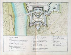
The building of Fort Lawrence was a terrible shock to the French. In retaliation Fort Beauséjour was built in 1751-52 according to a sophisticated plan inspired by Vauban by the French military engineer Louis Franquet. Here is his plan preserved in the National Archives in Ottawa, which shows both plan and section.
Detail of Louis Franquet, Plan du Fort de Beausejour Seitué sur le Continent du Canada dans le fond de la Baÿe françoise, coloured manuscript, 1751, Public Archives of Canada, MG 18, K 5.

Here is its profile, drawn in 1755 by Winckworth Tonge, an Irish British soldier at Fort Lawrence, from a point overlooking Ile de la Valliere in the middle ground, which he would eventually own and rename Tonge’s Island. The fort has an impressive profile and dominates the end of Beauséjour Ridge then as it does today.
Detail from Winckworth Tonge (1727 or 1728-1792) – A DRAUGHT/ of the ISTHMUS/ which joyns Nova Scotia/ to the Continent/ with the Situation of/ the ENGLISH and/ FRENCH FORTS &/ the Adjacent BAYS/ and RIVERS/ by W Tonge/ Chignecto Fort Lawrence 1755. British Library.

http://www.biographi.ca/en/bio/tonge_winckworth_4E.html
The fort fell in June 1755 when a shell lobbed by the English hit a bastion and exploded, killing both French and English officers in the casemate, or underground chamber, contained within it. It has been reconstructed by Parks Canada in the huge amount of work they did on the site in the 1960s.
Fort Beausejour becomes Fort Cumberland
After the conquest of Beausejour the English took over the very fine fort and abandoned Fort Lawrence which no longer had any use. It was renamed Fort Cumberland, and because of its critical location it was decided to repair and rebuild the fort. Responding to military anxiety it was decided to expand the fort and its surrounding earthworks on a quite massive scale, and this plan from 1761 outlines clearly the work that had to be done.
Bruce, Robert George, PLAN and SECTIONS of FORT CUMBERLAND in its Present State With the Additional Works Proposed, 1761, manuscript pen and ink with watercolour; 50 x 72 cm, British Library.

This work was never done, but military anxiety had been justified because the fort was attacked during the American Revolution (see Clarke).
The repair work on the fort after the 1755 conquest still survives in part, and one can see this rebuilding with fine stone and spectacular brick vaulting the various underground chambers.

Here is a model on view at the Fort Beausejour-Fort Cumberland Museum of the fort in its English phase.

Here is a painting, one of a series, done by the artist Lewis Parker that gives you a vivid feel for what life in Fort Cumberland might have been like.

You can see more of Parker’s historical reconstructions at this site.
http://lewisparker.ca/selectedworks/LifeatFortBeausejour.html
The fort continued to play an important role in the defense of Acadia/Nova Scotia until it was besieged by New Englanders during the American War of Independence in 1776. In time it fell into disuse, and then into ruin until interest in it was revived by Dr. Clarence Webster in the 1930s.
In this graphic panel prepared by Parks Canada you can see which parts of the French fort were preserved in the 1960s restoration. This is what you experience when you visit there today.

Check out these sites for more specific and detailed information on the forts.
https://www.pc.gc.ca/en/lhn-nhs/nb/beausejour
https://en.wikipedia.org/wiki/Fort_Beaus%C3%A9jour
Fort Gaspareaux
A small fort was built near Port Elgin near the mouth of the Gaspareaux River during the Abbé Le Loutre small war. The site is not well-known and seldom visited. Here is a sketch of it done after the conquest in 1756 by an English military engineer John Brewse, inset into a map of the surveyed parts of Nova Scotia. Brewse (or Bruce) did the first survey of what would become Halifax in 1749. He was wounded at the siege of Beausejour.
Detail from Brewse, John [Bruce, Richard John], A MAP OF THE SURVEYED PARTS OF NOVA SCOTIA MDCCLVI, manuscript pen and ink with watercolour; 51 x 71 cm, 1756, King George III Collection, British Library.

This is what Fort Gaspareaux looks like today. There’s not much to it and it is seldom visited, and the site often closed.

The British Colonial Period in Acadia and Ile St. Jean:
New Directions in Town Planning: Halifax
The English were determined to establish themselves in lucrative Acadia and so in 1749 built a centre of administration which they called Halifax, in honour of George Montague-Dunk, 2nd Earl of Halifax, who was the President of the Board of Trade. This moment of city planning in Acadia was a practical as well as a highly significant gesture in how to bring geometrical and rational order to the wasteland of the New World. The grid plan was based on the ancient Roman military camp, described in detail in the Liber de munitionibus castrorum (Book on fortifying a Roman camp) attributed to an architect called Hyginus, an old manuscript known from a Sixth Century transcription.
The English, having no other practical guide to exploiting unchartered wilderness, followed the example of the Romans as their empire expanded and began with the idea of the Roman military camp – a standard design for the Empire, and situated in a healthy location following the advice of another architect, Vitruvius. In this 1749 plan of the proposed city by Harris Moses we see the grid plan of the city, and in the best French Vauban-inspired tradition, fortifications at key points along the perimeter. Other cities in the wilderness would be laid out in this fashion during the next generation, giving us masterpieces of design. In 1768 Charlottetown would be laid out, then modified to include four green areas, whose origins until recently were full of mystery.
Harris Moses, A Plan of the Town of Halifax in Nova Scotia, engraving, 1749, Publish’d according to Act, Oct. 23d, By Edw’d Ryland, Price 6 d.

Conclusion
This story of the forts of Chignecto and Ile Saint Jean, with its surprising digression into the history of fortification and the great achievements of Vauban is a brief one, but it is one that connects to a much wider story from a point of view of architectural history. In this Atlantic region we tend to look at our architectural heritage with provincial eyes; in Prince Edward Island our sight is very insular. I have tried in this post to tell a story, with its roots in great antiquity, that might cause us to look at our military architecture with new eyes. Every detail has a source in the past.
When you study architecture, everything connects.
I began this post with a bizarre infra red photograph of Fort Beausejour/Fort Cumberland to grab your attention and make you wonder at the nature of this foreign object in our landscape. I finish the post with the same subject, but covered with the first snowfall of winter, that delineated its contours, volumes and lines in a new way, so that you see another face to this foreign object dominating the ridge of Beausejour. The landscape of Acadia, and of Ile Saint Jean, has been forever altered, and given a close relationship to the ancient and altered landscape of Europe and the Near East. Civilisation is a continuous process which never stops, and where connections are never-ending.

References
Boerefijn, W.N.A (Wim), The foundation, planning and building of new towns in the 13th and 14th centuries in Europe. An architectural-historical research into urban form and its creation. Phd. thesis Universiteit van Amsterdam, 2010.
Campbell, Duncan B., Fortifying a Roman Camp: The Liber de munitionibus castrorum of Hyginus, Bocca della Verita Publishing, Glasgow, 2018.
Clarke, Ernest, The Siege of Fort Cumberland, 1776: An Episode in the American Revolution, McGill-Queen’s University Press, Montreal, 1995.
Dubourg, Jacques, Histoire des Bastides – Les Villes Neuves du Moyen Age, Editions Sud Ouest, Imprimé par Polina à Luçon (85), 2002.
Gooding, S. James, An Introduction to British Artillery in North America, Museum Restoration Service, Bloomfield, Ontario, 1988.
Gooding, S.J., (introduction) Military Exercises: 1730, Museum Restoration Service, West Hill, Ontario, 1962.
Houlding, J.A., French Arms Drill of the 18th Century: 1703-1760, Museum Restoration Service, Bloomfield, Ontario, 1988.
Johnston, A.J.B., “Sébastien le Prestre de Vauban: Reflections on His Fame, His Fortifications, and His Influence,” French Colonial History, Vol. 3, Michigan State University press, 2003.
Kornwolf, James D and Georgiana Wallis Kornwolf, Architecture and Town Planning in Colonial North America, 3 vols., Johns Hopkins Univ Press, First Edition, 2002. (I have only seen a brief extract in another source.)
Lennox, Jeffers, “Nova Scotia Lost and Found: The Acadian Boundary Negotiation and Imperial Envisioning, 1750-1755,” Acadiensis, XL, No. 2, pp. 3-31, 2011.
Morris, A. E. J., History of Urban Form before the Industrial Revolution, Third Edition, Prentice Hall, London, 1994.
Muller, John, A Treatise Containing the Elementary Part of Fortification, Regular and Irregular, John Nourse at the Lamb, London, 1756, Reprinted by Museum Restoration Service, Ottawa, Ontario, 1968.
Muller, John, A Treatise of Artillery: Containing …, John Millar, Whitehall, 1780, reprinted by Museum Restoration Service, Bloomfield, Ontario, 1977.
Reps, John W., The Making of Urban America: A History of City Planning in the United States, Princeton University Press, Princeton, New Jersey, 1965.
Smith, Thomas Gordon, Vitruvius on Architecture, The Monacelli Press, New York, 2003.
Vachon, André, with Victorin Chabot and André Desrosiers, Taking Root: Canada from 1700 to 1760 in Records of Our History, Public Archives Canada, 1985.
Vauban, Traité des sièges et de l’attaque des places, Manuscript, Smithsonian Institution, 1700.
1700 Vauban – Traitté des siéges et de l’attaque des places – Smithsonian
Webster, John Clarence, The Forts of Chignecto: A study of the Eighteenth Century conflict between France and Great Britain in Acadia [With Plates, Including Portraits, and Maps], Privately Published, 1930.
Wolfe, General James, General Wolfe’s Instructions to Young Officers … , Second Edition, London, 1780, reprinted by Museum Restoration Service, Ottawa, Ontario, 1967.